
News
TV
Freeview
Freesat
Maps
Radio
Help!
Archive (2002-)
All posts by Briantist
Below are all of Briantist's postings, with the most recent are at the bottom of the page.
paul: To add to what Ian from notts says, another cause of such problems has been faulty street or "emergency" lighting.
It's clearly NOT 4G as that is on all the time.
| link to this comment |

David Bayliss: You won't get any English channels - the Freeview DTT signals don't reach beyond the UK's borders.
There are about 25 free-to-air channels on French DTT, most of which are in MPEG2.
So, if you have a Freeview HD box, you will get a few more channels.
| link to this comment |
Iain Davies : Except it's not.
The telecoms companies want the 700MHz band next.
Looks like they will get it from 2019, so in five years time there will have to be a whole new set of changes.
Le plus ca change, as they say.
| link to this comment |
James Kerr: you can use Freeview HD for now, or manual tune to one of the ITV England regions.
| link to this comment |
Paul Scott: Sorry, but there's no one to complain to, as you signed a bit of paper with this:

on it. Of your own free will.
More here Upgrading from Sky+HD to Freesat+HD | Freesat | ukfree.tv - 11 years of independent, free digital TV advice
| link to this comment |
MJ Ray: Thanks.
The "offical" maps bt ITV for Anglia http://www.itvmedia.co.uk.pdf shows the split thus:
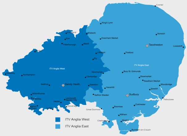
The maps here - ITV, UTV and STV regions - overview map - more or less match. The border is produced using the "strongest signal" rule.
The region maps - ITV Anglia (East micro region) and ITV Anglia (West micro region) show the overlap.
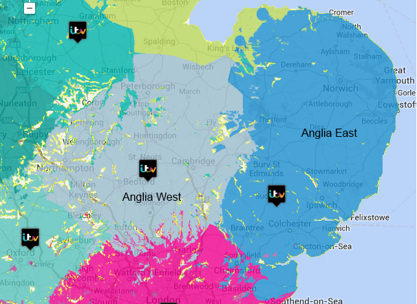
Of course, Sky and Freesat use postcodes which means you can put the border where you like.
| link to this comment |
MJ Ray: I don't mean to sound "defensive", but I am just going to quibble about the use of "overestimates" in your comment.
The maps on UK Free TV are computed, not hand-drawn. Taken into account is the best information about the transmitter heights, the output power and radiation patterns.
This is combined with OS mapping data and, much computing later (I use a 20 CPU instance on AWS) the maps are produced.
The computations used what I understand to be that industry standards and used internationally.
The only things I don't have is ground cover (ie, forest) information that would make winter/summer calculations better, and urban buildings data.
| link to this comment |
A COE : See Freeview intermittent interference | Freeview Interference | ukfree.tv - 11 years of independent, free digital TV advice for some suggestions...
| link to this comment |
Tuesday 30 July 2013 10:52PM
Tony: there are no analogue TV signals in the UK anymore....