
News
TV
Freeview
Freesat
Maps
Radio
Help!
Archive (2002-)
All posts by Briantist
Below are all of Briantist's postings, with the most recent are at the bottom of the page.
M. Bailey: The transmitter will carry the services listed at the top of the page, and no more. See Will there ever be more services on the Freeview Light transmitters? | ukfree.tv - independent free digital TV advice
The polarization of all transmitters remain the same at switchover.
| link to this comment |
Netbod: Do a photo of the problem screen on your phone, and then tweet it to @bbcredbutton Twitter . Use Twitpic - Share photos and videos on Twitter if you don't have the Twitter App on your phone.
| link to this comment |
Netbod: Here are the pics grabs if you need them - BBCi page 2510 option 5 page 1 on Twitpic and BBCi page 2510 option 4 page 1 on Twitpic .
| link to this comment |
n day: You need to take the VCR to the local recycing centre, it has no digital tuner and is no longer suitable for use.
Then you need to get a Freeview+ or Freesat+ hard-drive based recorder from a local store.
| link to this comment |
Mike Dimmick: Thanks, as ever, for your comments.
I was using "line of sight" as shorthand, but I'm using the Earth Curvature Correction - Earth Curvature Correction .
I have read the above publications many times (thanks). I have been involved in the broadcasting business for quite some years, as I am sure you recall.
As I am using the official radiation patterns, I am trying to map out the provided information and not re-create the planning conditions to deal with troposcopic propagation and other events - I am trying to provide a simple map to show the service area for each transmitter.
Whilst it might be interesting to know over-the-radio-horizon predictions for weather conditions, I think that trying to present the information would present considerable confusion.
Another issue is the information displayed needs to not cause too much server load. I will probably be using another AWS machine to host the mapping displays and there is a limit to how much I can pay for this.
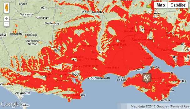
Anyway, the current state of the project is that it will display the interim data over the Google Maps correctly.
| link to this comment |
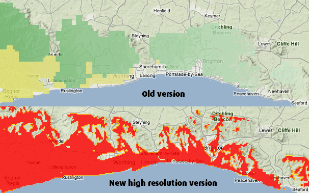
This example shows the improvement, due to having higher resolution data, around the coast:
| link to this comment |
Roy: Please see What does "Full HD Ready" actually mean? | ukfree.tv - independent free digital TV advice for help with that.
| link to this comment |
Howard: There are several advertising regions - please see Spot Advertising Macro Map | Channel 5 .
| link to this comment |
david: Thanks very much. Yes, this will be for all maps - when it's all completed. The pages showing for Ireland (NI and RoI) now show the new overlay format - see Digital TV transmitters in Ireland - update | ukfree.tv - independent free digital TV advice .
| link to this comment |
Thursday 9 February 2012 1:15PM
Andy Fraser: The engineering information is provided by the BBC, the wording is theirs and they do not wish it to be changed in any way.