Want better aerial to Freeview transmitter terrain plots? Check out UK Free TV!
 Brian Butterworth published on UK Free TV
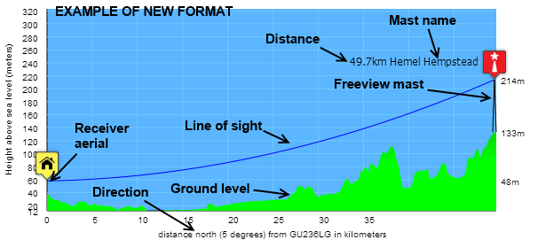
 The new terrain plot system (click here to see an example) has these features:
The images now have increased vertical size to make the diagrams easier to read.
The diagrams now have a proper vertical and horizontal scale, with grid lines in both directions.
For a chosen location, all the diagrams now use the same horizontal and vertical scale. The receiver location is always on the left hand side (the old version was centered).
The receiver aerial height, the transmitter mast ground level and transmitter element heights are show down the right hand side.
The compass baring (including the baring in degrees from north) is shown along the bottom of each diagram.
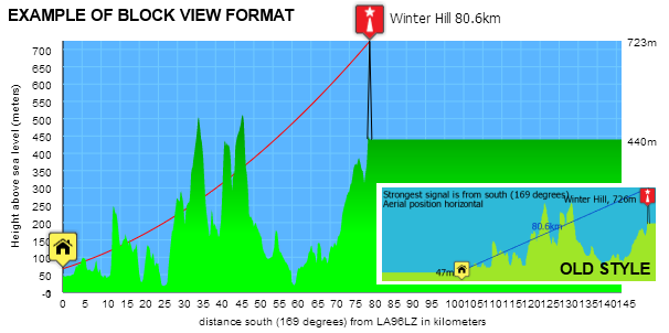
The line-of-sight is shown as a blue line, unless the line-of-sight is interrupted, when the line is red.

The line-of-sight now curves (a bit like a washing line) to show the effect of the Earth's curvature. In the old version, the line was shown straight, with the ground level adjusted. In the new version you can read off the true height above sea level from the diagram.
Some of the "friendly" visual style has been retained, with the blue representing the sky, green (fading into dark green or brown) the ground level. Also retained are the same symbols used on the maps for the location of the receiver (a house on a yellow background), and transmitter (a Freeview, Freeview Light or Saorview logo).

A few bug fixes
I have fixed few other problems:The "Opensearch" code wasn't working, which meant if you tried to search UK Free TV from the search box in Internet Explorer or Firefox (or similar Chrome feature) you didn't get any results. This is now working as expected.
Some DAB stations were not showing up. A DAB station that had a hyphen in the name would be missing from the DAB pages. These stations now show up correctly.
There was an issue with lower case in radio and DAB transmitters page links. This has now been fixed.
The UK Free TV comments by location page is working again.
Digital UK engineering information is being processed again.
6:07 PM
The terrain plots are fine for the transmitters listed at location 'Site settings'. But can a terrain plot be obtained somehow for other nearby transmitters not listed, which are also receivable? (+51.14,-000.04)
| link to this comment |
10:17 AM
Gillingham
I've suddenly lost my ITV channels on Freeview.
It's been fine till now.
My postcode is ME7 3NS.
| link to this comment |
Kevin's: mapK's Freeview map terrainK's terrain plot wavesK's frequency data K's Freeview Detailed Coverage
Mark Heselden: The listed transmitters are all those that can be received (with an aerial 10m above ground level). I'm not sure what benefit there is listing other transmitters?
The system did originally show all transmitters within the radio horizon, but it just confused people.
| link to this comment |
Ian: Where they have always been - My Freeview | ukfree.tv - 10 years of independent, free digital TV advice ...
| link to this comment |
10:17 AM
Is it possible to publish a list of all the forthcoming channel 8 freeview local stations, their coverage area and approximate on air dates? I'm sure this would be much appreciated as their is a strong demand for local news programmes.
| link to this comment |