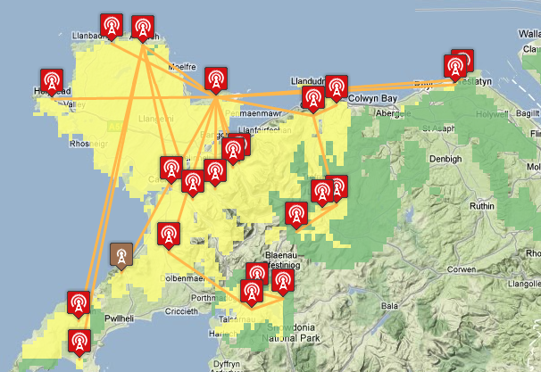
TV region maps now show network connections and transmitter types
 Brian Butterworth published on UK Free TV
 I have been considering this for a while, and I suspected it would be one of those "data entry on a rainy day" things to do - manually update the database so the UK Free TV mapping pages show the connections between the transmitters.
Using the information from the Transmitter Network - Digital UK Almanac I have updated the system to show the links between the transmitters, for example:

These are available for all switched-over regions, plus Oxford, minus (for some unspecified reason) the Carmel group in Wales and the Torosay and Selkirk groups in Scotland. Also missing is Stockland Hill in England.
If anyone has the Carmel, Torosay, Stockland Hill or Selkirk information, please let me know!
In addition, a separate symbol is now used to denote "Freeview Light" transmitters that only carry the public service multiplexes BBCA, D3+4 and BBCB, or will do after they have switched-over.
Your feed back is, as always, appreciated.
11:43 PM
I think maybe you need a different colour for each hop, as there are many lines crossing in several examples. Wenvoe is horribly complicated!
| link to this comment |
11:45 PM
Hi Brian
I'm probably being thick, but where are the Regional maps?
Is there a site map anywhere showing the structure of the available pages? Though I have been here for ages I still get confused and often rsort ot "Search" to find sat a particular Tx's page.
Thanks for all the good work. Hope you make something out of it
Steve
| link to this comment |
Mike Dimmick: That's a good point. I'll have a bit of a think about how that might be doable in code.
| link to this comment |
Steve P: They are in Tech Help/Region Maps.
There is a white-on-black site map in the footer of every single page.
All of the rest of the transmitter information is on the Freeview/Transmitters page.
| link to this comment |
8:19 AM
I've just noticed you have Malvern fed from Fenton, pretty much straight down the Welsh border! I think the dotted line in the Sutton Coldfield 'Almanac' diagram is intended to indicate that Malvern is line-fed from SC.
| link to this comment |
Mike Dimmick: I'm not sure, http://www.digitaluk.co.u….pdf the hexagon symbol is used in that way in other documents to denote an on-feed - as in the http://www.digitaluk.co.u….pdf document.
It would help if the Digital UK diagrams were consistent.
| link to this comment |
Mike Dimmick: I note that the layout of the
Transmitter Network - Digital UK Almanac page changed recently, did Carmel, Torosay, Stockland Hill and Selkirk go missing during the redesign or were they never published?
| link to this comment |
Digital UK have kindly sent me Carmel, Selkirk and Stockland Hill. I'll get on with adding their data to the database.
| link to this comment |
Briantist:
Very good
except the 'BBC one' icon looks like the transmitter has a fault icon when hidden behind a neighboring transmitter.
So you will need to ask the BBC to change the colour of their BBC one logo.
| link to this comment |
Mark's: mapM's Freeview map terrainM's terrain plot wavesM's frequency data M's Freeview Detailed Coverage