
 11:44 Read about new trends 20 new New UK Free TV articles 10 new Popular pages 10 new Your latest comments 10 new TV network faults 2 new 11:44 Read about new trends 20 new New UK Free TV articles 10 new Popular pages 10 new Your latest comments 10 new TV network faults 2 new
 DAB maps - another update
 Brian Butterworth published on UK Free TV
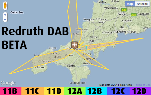
 Just a quick update to show a more advanced version of the DAB transmitter map for Kilvey Hill.
THIS IS A CORRECTED - BUT NOT FINAL - VERSION OF THE MAP
map is loading, please wait...
DEBUG
More updates soon.
All questions
In this section
Saturday, 11 June 2011
Even though SFNs, in away, hide many needs for coverage area consideration by many users it is still a very important asset in certain topographical locations - like mine! Soma maps I have seen suggest that Hastings Tx would just serve this location, but its actually behind/underneath a hill. So I guess coverage of Heathfield Tx is important to see mapped - about 20 years ago it was just possible to see the top mounted ANL, after dark on very clear nights. But DAB reception is not great here presumably the Heathfield Tx field strength is terrain limited at this location?
For these sort of reasons, I believe the pixel display is more useful than the "coverage area" display, because they show the small areas in shadow which do not show in area displays.
| link to this comment |

Monday, 13 June 2011
Ash: The point of SFN is that you don't create areas served by more than one transmitter if you can help it, thus when a new transmitter is introduced, neighbouring transmitter have their radiation patterns changed to avoid creating "mush zones".
| link to this comment |
Hi Briantist, there isn't a mush zone created in a DAB SFN! The neighbouring transmission sites in a DAB network do not have their radiation patterns changed when a new site comes on.
| link to this comment |
Ash: I suggest you do some reading up on how they work.
| link to this comment |
Jm F: The current map is using:
Distance=sqrt((ERPW)*(10^-db))/fpMinW)
Where fpMinW=7.94328234724E-12 (watts) which is -81 dBm, the minimum level for a DAB receiver.
There's some debugging to do, but the power is related to the distance squared, so does not fall off like a "radiation" diagram.
| link to this comment |
Bev MARKS: Here's Hastings
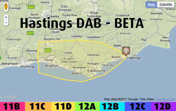
For some reason Heathfield has not imported ... I will have to find out why.
| link to this comment |
Tuesday, 14 June 2011
M
Mike Dimmick2:08 PM
Briantist: That Redruth map is utterly wrong. It should be fairly smooth from 0° round to 130°, with some ripple from 1.5 to 2.5 dB, then another lobe pointing to 250°.
Check that your angles are actually being treated as degrees by the maths functions, not as radians?
| link to this comment |
Briantist
Many thanks for these betas - I did say WOW to myself on sight of Redruth - didn't look right, since I had assumed it would cover the peninsula up to Newquay and St Austell roughly?
Hastings is interesting! It is now obvious that coverage where I am is outside the area (just to North), but there MUST be loads of deeply shadowed locations to the West, especially behind "Beachy Head" and the "Severn Sisters Downs" range, so it is hard to believe there will be coverage that far West in Brighton/Hove, deep below the Downs ridge, from Hastings. My previous point was that these 'no service' locations are not shown.
| link to this comment |
J
Jm F7:35 PM
Briantist: In the maths you've used:
"Distance=sqrt((ERPW)*(10^-db))/fpMinW)"
The 10^-db needs to be 10^-0.1dB. This restores the "normal" shape to the pattern.
Beyond that, I don't see how you get the pattern radius of around 53km (scaled off the Google Map sample for Redruth) using the Rx sensitivity. If I use ERP in W I get massive numbers. If I use ERP in kW it gets smaller but not nearly enough.
Ultimately, what's important is the radius for a 1kW source to give minimum receiver sensitivity. I'd guess around 50km max based on ITU-R P.1546-3 (100MHz land path, 50% time), and a field strength of 43dBV/m (near enough to your -80dBm).
The extra power from Redruth of 1.32kW then increases the max range a bit to 57.4km.
The maths then becomes:
Distance = (max range for a 1kW Tx).sqrt((ERP in kW).(10^-0.1db)), and the pattern is only a bit more "pinched" towards the centre than the regular HRP dB plot (using a 0 to 20dB scale).
Given that we've used a maximum range which is much less than the theoretical "free space" range, the "not so pinched" appearance of the regular HRP plot might actually match reality fairly well, as the ITU curves get a little closer to the "free space" value
| link to this comment |
Select more comments
Your comment please!